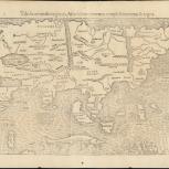
Map

Verso of Map
- Tabula orientalis regionis, Asiae scilicet extremas complectens terras & regna
- Geographia
- Münster, Sebastian, 1489-1552
- Ptolemy, active 2nd century
- [Publisher not identified]
- 1545
"The map contains many inaccuracies reflecting the lack of good, first-hand explorations of Asia. The Indian sub-continent is shown too small, whereas in contrast Southeast Asia is beginning to be depicted somewhat correctly. Ceylon, (Zaylon) once shown as a very large island, is now more its proper size, though two islands are shown in the immediate area." -- Dealer's description
;In Latin
- Scale not given.
- Caption title
- Relief shown pictorially
- From Sebastian Münster's revised edition of Ptolemy's Geographia universalis
- Latin text on verso entitled: Novata bvla Indiae et totius fere Asiae cum infinitis insulis, quae in ma and "12" appears on the border
- G7400 1545 .M86
- Asia
- Southeast Asia
- 1 map ; 26 x 35 cm
- 10.14711/spcol/991012528569103412
- https://digitalcollections.hkust.edu.hk/Detail/objects/991012528569103412