- Contained in (work) : China in European maps : a library special collection
- 福建、臺灣沿海地圖
- 詹志廉
- producer not identified
- between 1870 and 1930
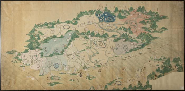
A spectacular large-scale manuscript map of Fujian, the northwest part of Taiwan, and Penghu. This map is much larger than the coastal scroll maps that typify indigenous Chinese cartography of the late 18th and early 19th centuries. It is an unusually detailed and artistic map compared to others of the genre. Principal administrative divisions are shown and color-coded. Main cities, settlements, and principal garrisons and fortifications are identified along the coastlines on both sides of the Straits of Taiwan.
- Scale not given.
- Relief shown pictorially.
- Title supplied by cataloger.
- Electronic reproduction. Hong Kong : Hong Kong University of Science and Technology Library, [2022].
- Originally created as: 1 map ; hand color ; 118 x 240 cm.
- Aspect ratio: 1:2.034.
- Description based on physical version.
- G7823.F8 1890 C43er
- Taiwan
- 福建
- 詹志廉
- Chinese
- 1 online resource (1 map, color)
- 10.14711/spcol/991013146518203412
- https://digitalcollections.hkust.edu.hk/Detail/objects/991013146518203412