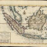
Map
Verso
- Nuoua carta delle Isole di Sunda, come Borneo, Sumatra e Java Grande &c
- Tirion, Isaak, 1705-1769
- Publisher not identified
- Between 1740 and 1750
- This map of Southeast Asia shows the Malay Peninsula, Sumatra, Java, and Borneo. Detailed with place names and a compass rose.
- Scale not determined
- Relief shown pictorially.
- Electronic reproduction: Hong Kong University of Science and Technology Library, [2022].
- Originally created as: 1 map : hand colored ; 26 x 35 cm, on sheet 33 x 41 cm.
- Aspect ratio: 1:0.808.
- Description based on physical version.
- G8000 1740 .T57er
- Southeast Asia
- East Indies
- per Jsaac Tirion
- Italian
- 1 online resource (1 map : hand colored)
- 10.14711/spcol/991013158536403412
- https://digitalcollections.hkust.edu.hk/Detail/objects/991013158536403412