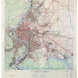
Map
Verso
- Thailand city maps. Changwat Phra Nakhon (Bangkok)
- Changwat Phra Nakohn (Bangkok)
- Prathēt Thai, phǣnthī tūa mư̄ang. Čhangwat Phra Nakhō̜n
- Changwat Phra Nakhon (Bangkok), Thailand
- Čhangwat Phra Nakhō̜n, Prathēt Thai
- United States
- The Battalion
- 1968
- Scale 1:17,000 ;
- "Compiled in 1968.".
- English and Thai.
- Alternate title: Changwat Phra Nakhon (Bangkok), Thailand = Čhangwat Phra Nakō̜n, Prathēt Thai.
- Standard map series designation: Series L9013.
- UTM grid: Zone 47P.
- Also distributed by Defense Mapping Agency, Hydrographic/Topographic Center.
- Includes boundary diagram and glossary.
- Indexes on verso.
- Electronic reproduction: Hong Kong University of Science and Technology Library, [2022].
- Originally created as: 1 map : color ; 91 x 83 cm, on sheet 115 x 90 cm.
- Aspect ratio: 1:1.241.
- Description based on physical version.
- G8029.B3 1968 .U5er
- Bangkok (Thailand)
- prepared under the direction of CINCUSARPAC by the 29th Engineer Battalion (Base Topo)
- English
- 1 online resource (1 map : color)
- 10.14711/spcol/991013158896703412
- https://digitalcollections.hkust.edu.hk/Detail/objects/991013158896703412