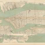
Map

Verso
- Atlas des ports étrangers
- France
- A Simon
- 1888
- Scale 1:20,000.
- Depths shown by contours and soundings.
- Oriented with north towards right.
- Atlas des Ports étrangers, 4e Série_PL. V.
- Includes two insets.
- Electronic reproduction: Hong Kong University of Science and Technology Library, [2022].
- Originally created as: 1 map ; 47 x 60 cm on sheet 52 x 67 cm.
- Aspect ratio: 1:0.774.
- Description based on physical version.
- G3804.N4P55 1888 .F7er
- Harbors
- New York (State)
- New York
- New York (N.Y.)
- Ministère des Travaux Publics
- French
- 1 online resource (1 map)
- 10.14711/spcol/991013158901803412
- https://digitalcollections.hkust.edu.hk/Detail/objects/991013158901803412