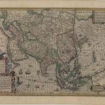
Map
Verso of Map
- Asia nova descriptio
- Hondius, Jodocus, 1563-1612
- Jodocus Hondius
- 1610
An improved outline of Asia appeared in this map. Jodocus Hondius' new map of Asia was designed to update the original Mercator map for the expanded editions of the Mercator-Hondius "Atlas". The cartography was improved by the adoption of the outline from the Ortelius-Teixeira map of Japan (1595), which identified Korea as an elongated island and showed the three principal islands of Japan.
- Scale 2 cm. = 75 German miles
- Relief shown pictorially
- Hand colored
- Includes text
- Published in the rev. ed. of the Mercator Atlas
- G7400 1610 .H65
- Asia
- Jodocus Hondius
- Latin
- 1 map : hand col. ; 38 x 50 cm
- 10.14711/spcol/b535869
- https://digitalcollections.hkust.edu.hk/Detail/objects/b535869