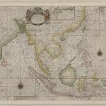
Map

Verso of Map
- East Indies
- Seller, John, active 1658-1698
- R & W Mount & T. Page
- 1748
This uncommon English chart of Southeast Asia was first published in 1702 in "Atlas Maritimus". It encompasses the region from southern India to Japan and northern New Guinea. The inset at the top right depicts parts of south and southwestern Japan. In the center, a decorative title cartouche has European depictions of "native figures" surmounted by the coat of arms of the English East India Company.
- Scale ca. 1:11,600,000
- Hand colored
- Navigational chart
- Inset: Japan
- G8001.P5 1702 .S45
- Nautical charts
- Southeast Asia
- John Seller
- English
- 1 map : hand col. ; 47 x 54 cm
- 10.14711/spcol/b536703
- https://digitalcollections.hkust.edu.hk/Detail/objects/b536703