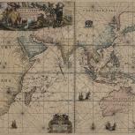
Map

Verso of Map
- Keulen, Johannes van, active 1726-1753
- by Ioannes van Keulen
- 1680
This important nautical chart was published in Johannes van Keulen's "Zee-Atlas" from 1680 onwards. It extends from South Africa to Japan and shows Indian Ocean and coasts of eastern Africa, India, East Indies, and an extensive coastline for Australia. Note the cartouche in the upper left where images of "Africa" and "The Orient" merge in Van Keulen's imagination.
- Scale not given
- Hand colored
- Navigational charts
- G9181.P5 1680 .K48
- Nautical charts
- Indian Ocean
- South Asia
- Southeast Asia
- Dutch
- 1 map : hand col. ; 52 x 59 cm
- 10.14711/spcol/b536704
- https://digitalcollections.hkust.edu.hk/Detail/objects/b536704