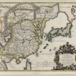
Map
Verso of Map
- Cantelli, Giacomo, 1643-1695
- Rossi, Giovanni Giacomo de, 17th cent
- Data in luce da Gio Giacomo Rossi ; Pace Co.
- 1682
Based on the reports of Giacomo Cantelli di Vignola, the important surveys of Martino Martini, and other travel accounts, this scarce Italian map of China, Korea and Japan was first published in Giacomo Rossi's "Mercurio Geografico" in Rome. Note the spectacular cartouche with a seated figure of the Great Khan.
- Scale [ca. 1:9,277,000] (E 135�°--E 195�°/N 20�°--N 45�°)
- Relief shown pictorially
- Hand colored
- Japan is modelled on the Cardim-Briet model
- G7820 1682 .C36
- China
- Japan
- East Asia
- da Giacomo Cantelli da Vignola
- 1 map : hand col. ; 45 x 56 cm
- 10.14711/spcol/b537420
- https://digitalcollections.hkust.edu.hk/Detail/objects/b537420