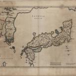
Map

Verso of Map
- Blaeu, Joan, 1596-1673
- Martini, Martino, 1614-1661
- 1655
A map of Japan and Korea from the first Western atlas of China, "Atlas Sinensis"
- Scale ca. 1 cm. = 4.87 German miles
- Relief shown pictorially
- Hand colored
- Appeared in: Martini's Atlas sinensis, between pp. 168-169
- G2306.S1 M3 1655 map 17
- Japan
- Korea
- Latin
- 1 map : hand col. ; 42 x 48 cm
- 10.14711/spcol/b537628
- https://digitalcollections.hkust.edu.hk/Detail/objects/b537628