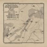
- Geological map of the epicentral area of the Lingshan earthquake of April 1, 1936
- 靈山地震震中區域地質圖
- Minguo er shi wu nian si yue yi ri Lingshan di zhen zhen zhong qu yu di zhi tu
- 陳國達, 1912-
- 兩廣地質調查所
- 兩廣地質調查所
- 民國25 [1936]
- Scale 1:133,333
- Chinese and English
- G7824.L57C55 1936 .C5
- Geology, Structural
- Seismology
- Lingshan Xian (Guangxi)
- 靈山
- 廣西
- 陳國達製 ; 兩廣地質調查所編製 = Geological map of the epicentral area of the Lingshan earthquake of April 1, 1936 / by Kuota Chan
- Chinese
- 1 map ; 28 x 32 cm., folded to 16 x 15 cm
- 10.14711/spcol/b921127
- https://digitalcollections.hkust.edu.hk/Detail/objects/b921127